ShutterstockC’mon Pacific Ocean, heat up or cool down. All this average crap is making us nervous.
Meteorologists base a lot of their long-term weather projections on temperatures in the globally influential Pacific Ocean. But for more than a year the world’s most expansive ocean has been devoid of its famed El Niño and La Niña patterns — anomalously higher-than-average or lower-than-average bands of sea-surface water that help govern major weather events.
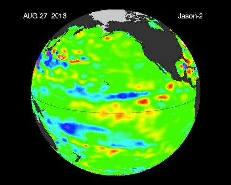
For now, the Pacific is stuck in a stubborn La Nada state: near-normal surface height and temperatures. Scientists say it could last into the spring, but that’s not so unusual: La Nada rules the Pacific about half the time. But it makes life difficult for weather forecasters, and it threatens to ignite unpredictably extreme weather. From NASA:
“Without an El Niño or La Niña signal present, other, less predictable, climatic factors will govern fall, winter and spring weather conditions,” said climatologist Bill Patzert of NASA’s Jet Propulsion Laboratory, Pasadena, Calif. Long-range forecasts are most successful during El Niño and La Niña episodes. The “in between” ocean state, La Nada, is the dominant condition, and is frustrating for long-range forecasters. It’s like driving without a decent road map — it makes forecasting difficult.”
Patzert noted that some of the wettest and driest winters occur during La Nada periods.
“Neutral infers something benign, but in fact if you look at these La Nada years when neither El Niño nor La Niña are present, they can be the most volatile and punishing. As an example, the continuing, deepening drought in the American West is far from ‘neutral,'” he said.

NASANASA uses satellite data to measure Pacific Ocean sea levels. Because warm water expands, that data helps scientists gauge the water temperature. All the green in this latest image means a whole lot average sea temperatures. And that means that La Nada is in town.


