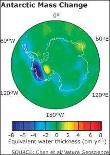
The East Antarctic ice sheet has been losing mass for the last three years, according to an analysis of data from a gravity-measuring satellite mission.
That’s from the BBC story. Nature Geoscience just published the study online, “Accelerated Antarctic ice loss from satellite gravity measurements.” It begins, “Accurate quantification of Antarctic ice-sheet mass balance and its contribution to global sea-level rise remains challenging, because in situ measurements over both space and time are sparse,” and it concludes:
Our results suggest that over the WAIS [West Antarctic ice sheet] (especially the ASE [Amundsen Sea Embayment]) there is accelerated ice loss since around 2005 and/or 2006, with the EAIS showing correlated changes of the same sign in this period, attributed to increased ice loss over EAIS coastal regions in recent years. Using a simple linear projection for the period 2006–2009, Antarctic ice loss rate can be as large as -220
89 Gt yr-1. These new GRACE estimates, on average, are consistent with recent InSAR fluxes4 but, in contrast to previous estimates, they indicate that as a whole, Antarctica may soon be contributing significantly more to global sea-level rise.
 The accelerated ice loss in WAIS is not a surprise to CP readers — see Nature: “Dynamic thinning of Greenland and Antarctic ice-sheet ocean margins is more sensitive, pervasive, enduring and important than previously realized.” Nor is the rapid loss at the ASE — the big blue blot in the figure [click to enlarge] — see Large Antarctic glacier thinning 4 times faster than it was 10 years ago: “Nothing in the natural world is lost at an accelerating exponential rate like this glacier.”
But ice loss in the East Antarctic ice sheet is definitely unexpected — the study leader Jianli Chen from the Centre for Space Research at the University of Texas in Austin told the BBC, “We felt surprised to see this change in East Antarctica.”
And it’s especially worrisome because EAIS contains vastly more ice than Greenland or WAIS:
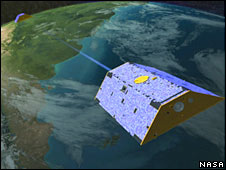
The data comes from Nasa’s Gravity Recovery and Climate Experiment (Grace) mission.
Grace has previously shown that the smaller West Antarctic and Greenland ice sheets are losing mass.
These two bodies of ice contain enough water to raise sea levels by about six to seven metres (20ft) each if they melted completely.
Melting the East Antarctic sheet would raise sea levels by much more — about 50-60m.
But scientists have generally discounted the possibility of it happening because the region is so cold.
Not any more.
The media and others keep repeating the IPCC’s outdated sea level rise projections, which were based on data that is now several years old, even thoughmany recent studies (see below) suggest the IPCC has significantly underestimated likely SLR this century on our current emissions path.
 The whole BBC piece is worth reading to understand the “tricky issue” involved in measuring Antarctic ice loss; the Grace satellite is depicted in the image. And Australian reporter Jennifer Macey has an excellent interview with Nathan Bindoff, professor in physical oceanography at the Antarctic Climate Ecosystems Cooperative research centre in Hobart, that sheds light on the new study:
BINDOFF: Every new estimate of the contribution of Antarctica to sea level rise has actually grown over the last four to five years and what that’s really telling us is, that our state of knowledge about Antarctica isn’t as good as we would like and it’s becoming clearer to us that there is a very significant risk of quite large sea level contributions into the future….
MACEY: Professor Nathan Bindoff says the new research shows that region is more sensitive to a changing climate than previously thought. And he says the 2007 IPCC report has underestimated the extent of future sea level rise caused by thinning ice in Antarctica.
NATHAN BINDOFF: And as we actually observe Antarctica literally shrinking in front of us, we understand that our estimates of that 22 centimetres from the ice sheets, Antarctica and a Greenland is almost certainly an underestimate.
And so the new numbers that people are extrapolating from these measurements, so it is a bit of an extrapolation, that what they’re saying is that there could be something like a metre to 1.5 metres for all of the contributions to sea level by 2100.
That is, unfortunately, becoming the mainstream projection in the scientific literature — see Startling new sea level rise research: “Most likely” 0.8 to 2.0 meters by 2100. While that 2008 study is often seen as definitive, it projects under 15 cm (6 inches) of SLR from Antarctica in its 0.8 m case and 62 cm (2 feet) in its 2.0 m case. Yet WAIS alone could exceed that, see “Q: How much can West Antarctica plausibly contribute to sea level rise by 2100?” [A: 3 to 5 feet].
A Science article from 2007 used empirical data from last century to project that sea levels could be up to 5 feet higher in 2100 and rising 6 inches a decade (see Inundated with Information on Sea Level Rise. Another 2007 study from Nature Geoscience came to the same conclusion (see “Sea levels may rise 5 feet by 2100“). Leading experts in the field have a similar view (see “Amazing AP article on sea level rise” and “Report from AGU meeting: One meter sea level rise by 2100 “very likely” even if warming stops?“). Even a major report signed off on by the Bush administration itself was forced to concede that the IPCC numbers are simply too out of date to be quoted anymore (see US Geological Survey stunner: Sea-level rise in 2100 will likely “substantially exceed” IPCC projections).
And don’t forget this 2009 study — Nature sea level rise shocker: Coral fossils suggest “catastrophic increase of more than 5 centimetres per year over a 50-year stretch is possible.” Lead author warns, “This could happen again.” And this one, too — “High Water: Greenland ice sheet melting faster than expected and could raise East Coast sea levels an extra 20 inches by 2100 — to more than 6 feet.”
Did I mention the time to act is now!
