
Back in January, Grist’s InterActivist column featured John Amos, the head of SkyTruth. SkyTruth uses satellite photos and digital mapping technologies to reveal what is difficult to see from the highway: just how exactly we’re changing our planet. Seeing a clearcut or a mine from a bird’s-eye perspective often adds a visceral dimension to an otherwise rather abstract-seeming issue.
One especially useful application for this sort of imagery: showing the extent of the havoc wrought by companies doing mountaintop–removal mining. Recently a coalition of Appalachian grassroots organizations, ILoveMountains.org, released a series of overlays for Google Earth showing "before" and "after" landscapes in several heavily-mined regions.
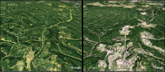
What really boggles my brain is that some of the mine footprints are visible in a view of the entire eastern half of the United States.
The Google Earth file is available here. A tutorial on how to download and use Google Earth to view the overlays is here.
A message from
Your support keeps our climate news free. All donations DOUBLED!
Grist is the only award-winning newsroom focused on exploring equitable solutions to climate change. It’s vital reporting made entirely possible by loyal readers like you.
At Grist, we don’t believe in paywalls. Instead, we rely on our readers to pitch in what they can so that we can continue bringing you our solution-based climate news. Donate today to keep our site free. All donations DOUBLED for a limited time.

